Using Drones for Energy (Industry)
The use of drones for energy infrastructures is and will continue to be the leading market for drone technology throughout the world. This is due to both the societal importance of energy production/maintenance and the exponential increase in safety and efficiency that drones bring to these operations. That is why we have prepared an Industry Report on this very topic, and here is a glimpse of what you can expect.
Implementing Drones for Energy-Related Operations
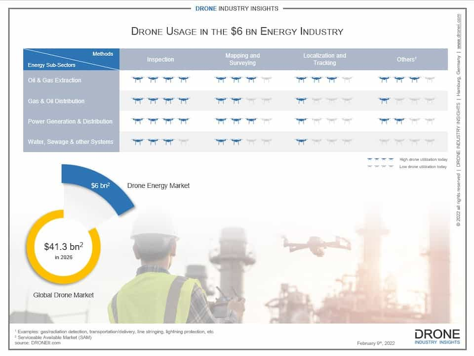
Globally, the Energy Industry provides crucial utilities such as electricity, oil, natural gas, steam, water, and wastewater disposal. These are vital resources that help society function. And thanks to a drone’s ability to access and record data, several types of drone applications are perfectly-suited to optimize processes in the Energy Industry. That is why the use of drones for energy is projected to become a US$6 billion market. Some of the activities that drones perform in this industry are for example: inspections, mapping & surveying, and localization & tracking.
Arguably, the key usage of drones for energy-related operations is “power generation and distribution”. However, this simple term encompasses a long list of infrastructures that includes: oil rigs, flare stacks, wind turbines, industrial facilities and powerlines. All of these involve large, robust infrastructures operating at high temperatures, high voltage, and/or high velocities. This makes them both very dangerous environments for humans to carry out necessary inspections and also equally-expensive objects to shut down (whether temporarily for an inspection or permanently because of overlooked critical damages). But the use of drones for energy-related operations such as these can translate into better and faster results, not to mention the fact that they put human’s out of harm’s way.
How Drones Help Inspections, Mapping, Surveying…
Drones can carry out inspections much more quickly and accurately than a human being. By flying around the object and using its camera (and additional sensors), drones capture more data and at higher quality than a person taking photos or notes. And re-positioning the drone is a matter of seconds rather than minutes (as it would be with a person climbing or hanging on to hazardous infrastructure). Additionally, using drones for energy-related inspections can also be less expensive. There is no need for scaffolding, cranes, or rope access, and there is a large reduction of working hours required to complete the inspection. There is also a very high indirect savings by not having to shut down the flare stack, turbine, or powerline for the inspection. And perhaps most importantly, the use of a drone for energy infrastructures instead of a human will keep these people out of dangerous situations.
Besides inspections, drones are also better at mapping and surveying objects thanks to LiDAR, thermal and other types of sensors that can be equipped on the drone to build better as-built models. Once again, depending on the drone’s equipment, these models can catch details with a 1mm per pixel accuracy and help render 3D models of an area. And when it comes to location and tracking tasks, drones can cover more area more quickly by air than a person on the ground. Perhaps the only similar alternative would be the use of a helicopter, though these can be extremely expensive.
Want to Know More About the Use of Drones in Energy? Check Out Our New Report!
Report | Drones in Energy Industry
• 92-page report with example drone applications, global market data, forecast, and company rankings for the energy industry
• Drone applications in energy including top industry sectors, application methods, typical results and technology stack + 6 real-life case studies
• Market data for drones in energy, broken down by region, top countries, and forecast including CAGR until 2026
• Company rankings for remote-sensing, commercial manufacturers and dual-use manufacturers
Full Industry Report about Using Drones for Energy
Other types of utilities using drones for energy operations include maintenance of solar panels; operating water treatment plants and/or water supply systems; maintaining sewer systems or sewage treatment facilities; providing steam, heated air, or cooled air, among several others. You can find an extensive list of these applications and methods as well as the approval processes required to carry them out in our full report.
The Drones in Energy Industry Report covers all drone applications as well as specific case studies with problem description, solution and technology used. The report also features market numbers for the global use of drones for energy, including the top countries and their expected growth. In addition, we include rankings of remote-sensing service providers as well as drone manufacturers that produces drones used for activities in the Energy Industry. Finally, there is a chapter on drone regulation and how this interacts with drone applications, including BVLOS operations.
Download our FREE Using Drones for Energy Infographic
This infographic, “Using Drones for Energy”, shows the various ways in which drones help optimize operations in the energy industry

Besides his financial oversight, Hendrik is an expert in aviation law and UAV regulation with more than 10 years of experience. Not only does he consult on all regulation questions, but Hendrik also writes the yearly drone investments report. Prior to launching DRONEII, at Lufthansa Technik he was the single point of contact to Civil Aviation Authorities (CAA) of Germany, Middle East and Asia.


